China Accelerometer Gyro Sensor manufacturer
Shenzhen Fire Power Control Technology Co., LTD
4
Home > Products > Inertial Navigation System >

MEMS Inertial Navigation System With High Reliability And Environmental Adaptability

Browse Categories

Shenzhen Fire Power Control Technology Co., LTD

City: shenzhen

Province/State:guangdong

Country/Region:china

Tel:86-755-23097872

View Contact Details

MEMS Inertial Navigation System With High Reliability And Environmental Adaptability

Brand Name AVIC
Model Number GI300D
Certification CE ROHS
Place of Origin CHINA
Minimum Order Quantity 1
Price negotiable
Payment Terms T/T
Supply Ability 500/month
Delivery Time 10 days
Packaging Details sponge+carton
Product name GI300D Inertial Navigation System
Attitude accuracy 0.1deg (rms)
Gyro range ±400°/s
Gyro zero bias stability ≤0.02°/h
Accelerometer range ±20g
Accelerometer zero bias stability ≤ 50 µg (10 s average)
Communication interface RS422/RS232/CAN/Network port
Voltage 12~36VDC
Detailed Product Description

MEMS Inertial Navigation System with High Reliability and Environmental Adaptability


Product Description


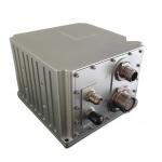
GI300D inertial navigation system  is based on high-precision closed-loop fiber optic gyroscope and accelerometer, and is realized through multi-

sensor fusion and navigation calculation algorithm. It provides high-precision attitude, speed, position and other information to meet the

requirements of high-precision measurement and control.


Main Application Fields


  • Large UAV Reference Inertial Navigation System
  • Marine compass
  • Self-propelled gun orientation
  • Vehicle positioning and orientation
  • High-precision mobile measurement
  • High precision stable platform
  • Fully mechanized coal mining


Key Functions


  • Inertial navigation realizes shearer walking track detection, with detection accuracy ≤ ± 30cm/300m working surface;
  • The built-in memory chip of the system saves the latest data in real time (including the data for a moment before the abnormal power failure), and can automatically recover according to the saved data after the power is on. The automatic recovery is completed within the starting and stabilizing time, and then the coal machine can be moved to maintain the accuracy requirements;
  • The inertial navigation system is installed on the shearer, and the user coordinates to provide the installation position, power supply, encoder information of the shearer and the Ethernet communication interface with the straightening system. The inertial navigation system can receive the encoder information through the CAN interface, and upload the three-dimensional attitude and shearer walking track (walking distance, measurement offset and height) data to the network link through the network port.


Technical Indicators
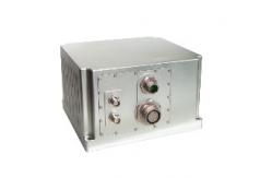
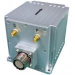
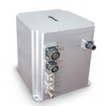
 

ProjectTest conditionsIndicators
Attitude accuracySelf-seeking north0.1 ° × sec (Lati), 15 min alignment of stationary base;
Attitude0.01°(RMS),
Fiber optical GyroscopeMeasuring range±400°/s
Zero bias stability≤0.02°/h
Quartz flexibility AccelerometerMeasuring range±20g
Zero bias stability≤ 50 µg (10 s average)
Communication interfaceRS4223 route(configurable to 232)
RS2322 Route
CAN2 route CAN
Network portOne network interface
Electrical characteristicsVoltage12~36VDC
Power consumption≤24W
Structural characteristicsInertial navigation host size188.8mm × 176.8mm × 117 mm (L × W × H)
Weight of the main engine≤5kg


Product Structure


                 L188.8mm x W176.8mm x H117m(L x W x H) 

Product Tags: Environmental Adaptability Inertial Navigation System   MEMS Inertial Navigation System   High Reliability Inertial Navigation System  
Related Products
Email to this supplier
 
From:
Enter your Email please.
To: Shenzhen Fire Power Control Technology Co., LTD
Subject:
Message:
Characters Remaining: (80/3000)