
High heading accuracy Integrated Navigation System with MEMS and Satellite Navigation Technology
|
|
High heading accuracy Integrated Navigation System with MEMS and Satellite Navigation Technology
Product Description
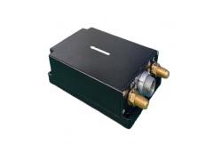
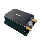
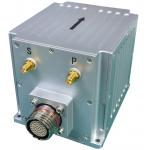
The GI100E-A0-DGI integrated navigation system has built-in high-performance MEMS gyroscope and accelerometer, which can receive internal GNSS data, realize multi-sensor fusion and integrated navigation solution algorithm, and have short-term inertial navigation capability when GNSS is invalid. The product has high reliability and strong environmental adaptability. By matching different software, the products can be widely used in the fields of tactical and industrial unmanned aerial vehicles, unmanned vehicles, unmanned ships, aviation guided bombs, intelligent ammunition, rockets, mobile communication, mapping, seeker and stable platform.
Technical indicators
Main Features
The integrated navigation system can carry out integrated navigation by using the satellite navigation information received internally, and output the pitch, roll, course, position, speed, time and other information of the carrier; After losing the satellite signal, it outputs the position, velocity and attitude information of inertial solution, and has a certain navigation accuracy maintenance function in a short time.
Product Dimensions
L80mm x W53mm x H23mm(L x W x H)
|
||||||||||||||||||||||||||||||||||||||||||||||||||||||||||||||||||||||||||||||||||||||||||||||||||||||||||||||
| Product Tags: High heading accuracy Integrated Navigation System Satellite Navigation Integrated Navigation System MEMS Integrated Navigation System | ||||||||||||||||||||||||||||||||||||||||||||||||||||||||||||||||||||||||||||||||||||||||||||||||||||||||||||||
|
GNSS Fiber Optic Gyroscope , Inertial Navigation System RTK for Marine Navigation |
|
Low Zero Stability Integrated Navigation System With Fiber Gyro And Mems Acceleroemter |
|
Low Cost Mems Integrated Navigation System with RS232/RS422 Output |
|
High Heading Accuracy Gnss Gps Module Rtk Antenna Inertial Navigation System for Marine Navigation |
|
High Precise Inertial Navigation System GPS Inertial Navigation Sensor |
|
Ins500 Fiber Ins Navigation System Closed Loop High Precision |