high performance INS based on MEMS inertial navigation RTK INS for
unmanned driving
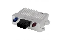
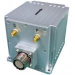
INS570D is a high performance integrated navigation product based
on MEMS inertial navigation technology, which integrates satellite
navigation information (supporting RTK) and vehicle information
(wheel speed, gear, etc.), and adopts vehicle design. It has the
ability to accurately provide attitude, heading, position, speed,
sensor data and other information to vehicles through data bus in
various scenarios (highway, bunker, viaduct, tunnel, city street,
port, etc.). The product adopts good man-machine design, which can
indicate power supply status, satellite information access status,
vehicle information access status, equipment status and other
information to the user through the indicator light. The hardware
(connector) interface adopts error-proof design, which is
convenient for user production, scientific research and debugging.
| Indicators |
| SYSTEM |
| Roll/pitch(1σ) | 0.1° |
| GPS lockout accuracy(Vehicle CEP) | Position drift(1km or2min) | 0.20%(With odometer calibration) |
| | Heading drift(1min) | 0.15° |
| GYRO |
| Range | 250°/s |
| Bias stability | ≤10°/h |
| (10s Average) | |
| Bias instability | 4°/h |
| (1σ) | |
| Bias in full temperature | ≤0.07°/s |
| ARW | <0.35°/√h |
| nonlinear | <200ppm |
| Cross coupling | <0.05° |
| Bandwidth | 168Hz |
| ACCELEROMETER |
| Range | 4g |
| Bias stability | ≤0.1mg |
| (10s average) | |
| Bias in full temperature | ≤2mg |
| Velocity random walk | <0.04 m/s/√hr |
| nonlinear | <300ppm |
| Bandwidth | 400Hz |
| Satellite navigation board |
| Position(RMS) | 1.5m,2cm+1ppm(RTK) |
| Speed(RMS) | 0.03 m/s |
| Heading(RMS) | 0.2°(Base line1m) |
| Frequency band | BDS B1/B2 + GPSL1/L2 + GLONASSL1/L2+ Galileo E1/e5bE + SBAS/QSZZ |
| Electrical interface |
| Voltage input | 12V (DC 9~16V) |
| Working current | ≤0.5A |
| Interface type | RS422 *1(Data port),RS232 *1(Difference mouth), CAN *2 |
| Connector type | MX23A18NF1,FAKRA_C/D |
| Host |
| Weight | <310g |
| Size | 116*99.78*30mm |
| Shell material | Aluminum alloy |