
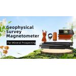
Geophysical Magnetometer Proton Magnetic Exploration
|


|
Geophysical magnetometer proton magnetic exploration
Introduction:
WCZ-1 proton magnetometer developed especially for home practical instance by referring abroad technique. It can measure magnetic in precision of 1nT. The resolving power can reach 0.1nT. These are in accord with the requirement of former Ministry of Geologic and Mineral, China. Its large memory, high resolution, agility make it a portable, mobile, base station fitted magnetometer. By changing the structure of the sonde, it can make the horizontal gradient measurement and the vertical gradient measurement at are solution of 0.1nT.
Technical specification:
Application:
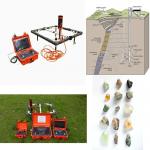
1. Mineral prospecting, such as iron ore, lead-zinc, copper mine. 2. Cooperative mine prospecting, study, the ore body`s burial depth, dipping and continuity, study the ore body`s shape, size, estimate mineral bed`s scale. 3. Prospecting for gas or oil, research geologic structure relevant to gas or oil. 4. Geologic survey, geologic mapping. 5. Ground diurnal variation for aero-magnetic and marine magnetic survey. 6. Faults orientation. 7. Archaeology. 8. Hydrology. 9. Engineering prospecting, e.g, pipeline finding. 10. Earthquake monitoring, volcano monitoring, and other environmental and disaster. 11. Small ferromagnetic objects finding.
Geophysical magnetometer proton magnetic exploration
Feature:
1. The host has built-in GPS antenna and lithium battery module and GPS module. It is more convenient and reliable. 2. Rapid measurement - just 2 seconds from the start of the measurement to the display reading. 3. Full automatic tuning range, also can be manual tuning. 4. Perfect way of GPS navigation function: support text files into line and the coordinates of each point can be measured through the preset line endpoint, the coordinates of the instrument is calculated for each measuring point coordinates. 5. Mass data storage - hold in every measurement point magnetic field measurements, the coordinates of measuring points, elevation, and the information such as time, environment temperature, the data can be stored up to 2 million points. 6. Light weight and portable - the system uses backpack straps, one person can complete all the measurement task. 7. Standard software can draw isoline map, section and track diagram etc. It can also work on diurnal variation correction.
Detailes: |
|||||||||||||||||||||||||||
| Product Tags: Proton magnetometer Magnetic Exploration magnetometer Geophysical magnetometer |

|
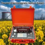
WTEM-3Q Model Transient Electromagnetic System with 12V Rechargeable Battery for Deep Mineral Exploration |

|
Controlled Source Audio Magnetotellurics Geophysical Sensor Calibration System Industrial EMI Rejection Magnetotellurics |
|
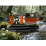
WTEM Transient Electromagnetic System for Quick Survey with Flexible Configuration High-Power Transmission and Deep Penetration |
|
Professional Metal Detector Deep Soil Metal Scanner Anti-Interference Magnetometer |
|
Underground Metal Detection Equipment Geophysical Survey Magnetometer Earth Magnetic Field Meter |
|
Underground Water Finder Transient Electromagnetic Equipment Resistivity Imaging System |