
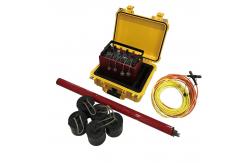
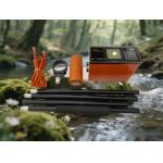
MT AMT CSAMT Magnetotelluric Electromagnetic Underground Geophysical Exploration Instrument
|


|
MT AMT CSAMT Geophysical Magnetotelluric Equipment Underground Exploration Electromagnetic Instrument
Product Feature High-frequency magnetotelluric sounding (100 kHz–10 kHz) can be utilized to explore depths ranging from a few meters to a thousand meters, where human activity is most active. Long-period magnetotelluric sounding (10 kHz–0.1 Hz) or audio magnetotelluric sounding (10 kHz–0.1 Hz) can also be used. (1kHz-10000s) or broadband electromagnetic sounding (10kHz-10000s) to conduct deep macro-geological investigation.
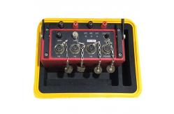
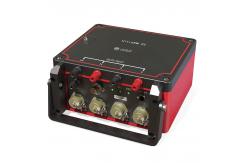
1.Mixing mode of natural and artificial sources Natural sources (MT, AMT) and artificial sources (CSAMT, IP, TEM) and other electromagnetic approaches can be used; micromotion monitoring and traditional seismic data recording can also be used. 2.Both tensors and scalars are observable Tensor measurements of two- and three-dimensional geological features can be done, in addition to scalar measurements appropriate for quick censuses. Portable on-site real-time imaging 3. uses an embedded real-time operating system with parallel hardware processing The apparatus achieves full-band acquisition while recording the optical and electromagnetic field power spectrums at the same time. In addition to being able to be field seen, apparent resistivity and phase profiles of a scalar or tensor can be computed in real time on the spot. 4.Efficient real-time parallel collection with multiple sampling rates 24kHz, 2400Hz extraction recording, 150Hz,15Hz continuous recording enables efficient EMAP continuous recording observation
Technical Parameters
Application Area
Certification
About Us
1. We provide one-year warranty, during this period, we are responsible for any mechanical failures or faults caused by design technology or material and handle any improper errors for free; we will still provide free technical assistance beyond this period (only charge parts' cost price and traveling allowance). 2. If there are any failures because of our products' quality in use, we will provide the phone instructions within 2 hours to help solving the problems, and we will supply on-line video technical communication if necessary. 3. We can dispatch the experienced engineer for installation and debugging after receiving the customer's notification. 4. We will provide free training, installation, debugging service in China, it is also available to send professional staff overseas for installation and debugging, only the traveling costs and labor costs will be borne by you. 5. After sale, we provide regular phone service to collect the customer's suggestions and advice.
Shipping And Delivery
|
||||||||||||||||||||||||||||||||||||||||||||
| Product Tags: CSAMT Geophysical Exploration Instrument Underground Magnetotelluric Instrument Electromagnetic Geophysical Exploration Instrument | ||||||||||||||||||||||||||||||||||||||||||||

|
WTEM-3Q Model Transient Electromagnetic System with 12V Rechargeable Battery for Deep Mineral Exploration |

|
Controlled Source Audio Magnetotellurics Geophysical Sensor Calibration System Industrial EMI Rejection Magnetotellurics |
|
WTEM Transient Electromagnetic System for Quick Survey with Flexible Configuration High-Power Transmission and Deep Penetration |
|
Professional Metal Detector Deep Soil Metal Scanner Anti-Interference Magnetometer |

|
Underground Metal Detection Equipment Geophysical Survey Magnetometer Earth Magnetic Field Meter |
|
Underground Water Finder Transient Electromagnetic Equipment Resistivity Imaging System |