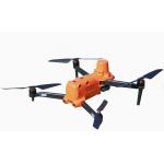
Product Descriptin X1 quadrotor flight platform is a portable quadrotor flight platform specially designed for small area aerial photogrammetry. With the concept of "control points-free and flexible operation", it can meet the needs of extremely low input cost, extremely low difficulty in getting started and extremely flexible operation mode. 1. Base-station free
No need to erect a base station, real-time centimeter-level
positioning and PPK post-processing solution
2. High accuracy
No control points are required up to 1:500
3. More safety
6 binocular 720° omni-directional obstacle avoidance design, with omni-directional "observation" obstacle
capability, for flight safety escort
4. More effective
No assembly, unfurl and fly, single sortie operation can reach more than 36 minutes Product Parameters | Aircraft | | weight | 1237g | | wheelcase | 397mm | | Maximum flight time | 36mins(No wind conditions | | Maximum wind resistance | Strong gale up to LV.8 | | Maximum take-off altitude | 6000m | | Radio operating frequency band | 2.4GHz To 2.4835GHz | | Hover accuracy | When RTK is enabled and RTK works Horizontal: ±0.1m Vertical: ±0.1m | Without RTK enabled: Horizontal: ±0.3m (when visual positioning is working normally)
±1.5m (when GNSS positioning is working normally) Vertical : ±0.1m (when visual positioning is working normally)
±0.5m (GNSS positioning when normal operation) | | RTK module | | Frequency point | GPS:L1/L2 GLONASS:L1/L2 Beidou satellite: B1/B2 Galileo satellite:E1/E5 | | Time to first fix | <50s | | Positioning accuracy | Horizontal:1cm+1ppm (RMS) Vertical: 1.5+1ppm (RMS) | | Camera | | Sensor type | 1 inch CMOS, 20 million effective pixels | | Field angle | FOV82° | | Camera aperture | f/2.8-f/11 | | Focusing range | 1m to infinity | | Equivalent focal length | 28.6mm | | Zoom range | 1-8x (maximum 3x lossless zoom) | | item | value | | Warranty | 1 year | | Customized support | OEM, ODM, OBM | | Place of Origin | China | | | Shanghai | | Brand Name | CHCNAV | | Model Number | AlphaAir 450 | | Product name | CHCNAV Airborne LIDAR System AlphaAir 450 | | GNSS system | Dual-frequency GNSS GPS, GLONASS, BeiDou, Galileo | | Absolute accuracy | <10 cm Hz <5 cm V | | Communications | 1*port for GNSS antenna Skyport interface 1*USB Type-C | | Data storage | 256 GB | | Max. returns supported | Up to 3 | | Laser class | 1 (in accordance with IEC 60825-1:2014) | | Camera type | Built-in calibrated Camera | | Precision | 15 mm | | IMU update rate | 500 Hz | Certifications 
FAQ 1. who are we?
We are based in sichuan, China, start from 2016,sell to Africa(30.00%),Southeast Asia(16.00%),Mid East(11.00%),Eastern
Asia(10.00%),South America(10.00%),Central America(5.00%),South Asia(5.00%),Southern Europe(5.00%),North America(4.00%),Eastern
Europe(4.00%). There are total about 11-20 people in our office.
2. how can we guarantee quality?
Always a pre-production sample before mass production;
Always final Inspection before shipment;
3.what can you buy from us?
GNSS RTK,Total station,Level,Survey accessory,laser rangefinder
4. why should you buy from us not from other suppliers?
1.More than 20 years of experience in the trade field. 2.All products will have been strictly quality checked in factory before
sending out and all products have one year warranty.
5. what services can we provide?
Accepted Delivery Terms: FOB,CFR,CIF,EXW,FAS,CIP,FCA,CPT,DEQ,DDP,DDU,Express Delivery,DAF,DES;
Accepted Payment Currency:USD,EUR,JPY,CAD,AUD,HKD,GBP,CNY,CHF;
Accepted Payment Type: T/T,L/C,D/P D/A,MoneyGram,Credit Card,PayPal,Western Union,Cash,Escrow;
Language Spoken:English,Chinese,Spanish,Japanese,Portuguese,German,Arabic,French,Russian,Korean,Hindi,Italian |