Water Area Monitoring Multi-sensor SystemElevate your water monitoring strategies with our state-of-the-art
multi-dimensional joint perception system. This comprehensive
solution employs cutting-edge technologies like monitoring radar,
Automated Identification System (AIS), optical video, and unmanned
aerial vehicles, ensuring a robust and reliable detection,
identification, and tracking of small targets in challenging
aquatic environments. Marvel at its ability to guide radar optical
equipment for precise tracking, photography, and evidence
accumulation. With the power of multi-dimensional data fusion,
image recognition, and AI-driven algorithms, it proficiently
identifies illegal activities such as unauthorized fishing, sand
mining, maritime smuggling, and immigration. Experience automation
at its finest with features like machine search, alarm, and
evidence collection. This versatile system can be seamlessly
integrated into various applications, including smart fishery
management, intelligent fishing ports, advanced sand control
systems, coastal defense enhancements, offshore energy facilities,
and infrastructure protection like bridge collision prevention.
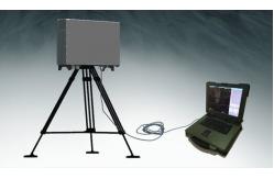
Centers Mobile Platform
performance
Introducing the LW-R25-SG, a solid-state pulse compression radar
designed for superior water monitoring capabilities. As an
evolution of the LW-R25-SC model, this radar showcases an array of
advanced technologies, including solid-state transmitters, digital
signal processing, multi-waveform pulse compression, and
Sensitivity Time Control (STC). These innovations confer the
LW-R25-SG with unparalleled detection range, minimal blind spots in
close-range detection, and exceptional tracking precision, ensuring
accurate target acquisition. Perfectly suited for applications in
smart fishery management, intelligent fishing ports, modern smart
ports, and enhanced border defense strategies.
Technical Parameter
| project | index |
| Operating Frequency | 9370±160MHz |
| peak power | ≥150w |
| power | 12.0km (RCS>1 m², height 2m, Pd=0.8, Pf=10-6) 20.0km
(RCS>10m, height 2m, Pd=0.8, Pf=10-6) 60km (RCS 21000 m², height
10m, Pd=0.8, Pf=10-6) |
| resolution ratio | ≤200m |
| positioning accuracy | Distance resolution: ≤ 15m
Speed resolution: ≤ 1m/s |
| power | Distance accuracy (root mean square): ≤ 8m
Azimuth accuracy (root mean square): ≤ 0.3 |
| reliability | 300W |