Water Area Monitoring Multi-sensor SystemIntroducing our cutting-edge multi-dimensional joint perception
system for water monitoring—a state-of-the-art, comprehensive
solution engineered to revolutionize aquatic surveillance. This
advanced system leverages a blend of monitoring radar, automatic
ship identification systems (AIS), optical video technology, and
unmanned aerial vehicles as its primary sensory tools, delivering
unparalleled capabilities in detecting, identifying, and tracking
small targets within intricate aquatic environments. Our
sophisticated radar-guided optical equipment ensures precision
tracking, photography, evidence collection, and alarm
functionalities. By harnessing the power of multi-dimensional data
fusion, image recognition, and AI-driven algorithms, this system
excels in identifying unlawful activities such as illegal fishing,
unauthorized sand mining, maritime smuggling, and illegal
immigration. With seamless integration and automatic machine
search, detection, and alarm functionalities, it offers rapid
evidence collection, transforming operations in smart fishery
administration, smart fishing ports, intelligent sand control,
coastal defense, offshore oil and gas fields, wind power plants,
and bridge collision prevention.
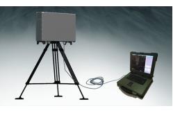
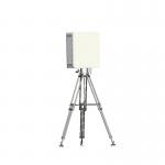
Centers Mobile Platform
performance
Discover the LW-R25-SG, a solid-state pulse compression water
monitoring radar, representing a significant leap forward in radar
technology. This innovative model is an evolved version of the
renowned LW-R25-SC, boasting superior technical specifications that
outshine its predecessor. Featuring cutting-edge technologies
including a solid-state transmitter, digital signal processing,
multi-waveform pulse compression, and sensitivity time control
(STC), this radar is designed for excellence. It offers an
impressive long detection range, minimal blind spots for
close-range detection, high tracking accuracy, and precise target
tracking, making it an invaluable asset for smart fishery
administration, advanced fishing ports, intelligent ports, and
strategic border defense.
Technical Parameter
| project | index |
| Operating Frequency | 9370±160MHz |
| peak power | ≥150w |
| power | 12.0km (RCS>1 m², height 2m, Pd=0.8, Pf=10-6) 20.0km
(RCS>10m, height 2m, Pd=0.8, Pf=10-6) 60km (RCS 21000 m², height
10m, Pd=0.8, Pf=10-6) |
| resolution ratio | ≤200m |
| positioning accuracy | Distance resolution: ≤ 15m
Speed resolution: ≤ 1m/s |
| power | Distance accuracy (root mean square): ≤ 8m
Azimuth accuracy (root mean square): ≤ 0.3 |
| reliability | 300W |