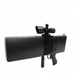
Multi-sensor for All-round Protection Radar Defensive System
Safeguards Critical Zones Ⅰ. Product Description The Multi-sensor for All-round Protection Radar
Defensive System is an advanced, integrated security solution
designed to safeguard critical zones with unparalleled precision
and reliability. By leveraging cutting-edge radar technology
combined with multi-sensor fusion, this system provides
comprehensive detection, tracking, and threat assessment
capabilities. Ⅱ. Product Features 1. Multi sensor Fusion Technology Combines radar, thermal imaging, optical cameras, and AI analytics
for superior detection accuracy. Reduces false alarms through cross-verification from multiple
sensors. 2. 360 Degree Surveillance Coverage Omnidirectional radar scanning ensures no blind spots in critical
zones.Adjustable detection range and sensitivity for customized security
perimeters. 3. AIPowered Threat Recognition Machine learning algorithms classify and prioritize threats (e.g.,
drones, vehicles, personnel).Automated alerts with real-time tracking and predictive analysis.
4. All Weather Day/Night Operation Thermal imaging and radar penetration capabilities ensure
functionality in fog, rain, snow, and complete darkness. 5. Modular Scalable Design Easily expandable with additional sensors or integration into
existing security networks.Supports remote monitoring and centralized command control. 6. Rapid Deployment Low Maintenanc Lightweight, ruggedized construction for quick installation in
diverse environments.Self-diagnostic features minimize downtime and maintenance costs.
Ⅲ. Product Functions 1. Dynamic Target Detection Tracking Radar Detection: Continuously scans the environment to detect
moving objects within a specified range.Multi-target Tracking: Simultaneously tracks multiple threats with
real-time trajectory analysis. 2. Intelligent Threat Classification AI-Based Identification: Differentiates between humans, vehicles,
drones, and animals.Risk Assessment: Assigns threat levels based on speed, size, and
movement patterns. 3. Automated Alarm Response Integration Instant Alerts: Notifies security personnel via visual/audible
alarms or mobile notifications.Integration with Countermeasures: Can trigger automated defense
mechanisms ( jamming, barriers). 4. Multi Sensor Data Fusion Cross-Verification: Combines radar, thermal, and optical data to
eliminate false positives.Enhanced Situational Awareness: Overlays threat data on a digital
map for real-time monitoring. 5. Remote Monitoring Control Cloud-Based Management: Access live feeds and system controls from
any authorized device.Customizable Dashboards:Displays critical metrics and alerts based
on user preferences. 6. Adaptive Scanning Modes Adjustable Detection Range:Configurable for short, medium, or
long-range surveillance.Focus Zones: Prioritizes scanning in high-risk areas while
maintaining general perimeter coverage. 7. Data Logging Forensic Analysis Event Recording: Stores detection logs, video footage, and system
responses for post-incident review.Forensic Playback:Allows reconstruction of security breaches for
investigation. Ⅳ. Product Parameter Functional indicators | Standard configuration | UAD-XTF-PZGLE05 (radar, spectrum, electro-optical, jamming,
deception, controller, and management software) | Detection distance | ≥5KM | Detection frequency band | 70 MHz to 6000 MHz, Note: Other frequency bands can be customized | Deceptive frequency | GPS/GALILEO/GLONASS/Beidou | Deceptive distance | ≥1KM | Interference frequency band | 5900-6200MHz/5600-5950MHz/5100-5350MHz | 4850-5100MHz/2280-2540MHz/1750-2000MHz | 1100-1400MHz/850-1050MHz/720-950MHz /410-520MHz | radar parameters | Detailed parameters are listed below: Radar module performance
parameters | optoelectronic parameters | Photovoltaic parameters Detailed parameters are listed in the table
below *④ Photovoltaic module performance parameters | Mechanical indicators | wind resistance | 10strong wind | Operating temperature | -40℃~55℃ | Storage temperature | -45℃~65℃ | protection rating | IP65 | Operating humidity | ≤ 95% | data interface | RJ45 | power port | Voltage: 220V Power: ≤550W (Detection Mode), ≤1950W (Countermeasure Mode) | weight | 250KG | Size | 850mmx850mmx1700mm | Platform features | Whitelist and blacklist, real-time detection, optical tracking,
automatic countermeasures, manual countermeasures, GIS map. Data
storage, event query. | Spectrum detection module indicator parameters | Detection frequency band | 20MHz-6GHz | Detection radius | ≥5km | Identify the radius distance | ≥5 kilometers, can recognize some drone brands and models | Detection angle | 360° | Angular measurement accuracy error (root mean square) | Distance of 5 km or more ≤ 1° | Minimum detection altitude | <0m | Interference module indicator parameters | Interference frequency band | 5900-6200MHz | 5600-5950MHz | 5100-5350MHz | 4850-5100MHz | 2280-2540MHz | 1750-2000MHz | 1100-1400MHz | 850-1050MHz | 720-950MHz | 410-520MHz | power port | 50W | Interference distance | 3KM | Radar module parameters | Work system | Phased array system (azimuth scanning+elevation phase scanning) | Working frequency band | Xband | Effective detection power | ≥5.0KM(UAV) | ≥8.0KM(Pedestrians) | ≥10.0KM(vehicles) | ≥5.0KM(boats) | Detecting speed | 0.5m/s-83m/s | Azimuth accuracy | ≤0.3°(search for);≤0.3°(track) | Pitch accuracy | ≤1.0°(search for);≤0.5°(track) | Data rate | ≤5s/circle | Optoelectronic module index parameters | Operating distance | In the case of atmospheric visibility ≥ 20km, humidity ≤ 50% RH,
and temperature difference>6K,Visible light detection distance ≥
5000m, tracking distance ≥ 4000m, recognition distance ≥ 3000m for
0.3m × 0.3m unmanned aerial vehicle targets; thermal imaging
detection distance ≥ 1500m, tracking distance ≥ 1000m, recognition
distance ≥ 1000m | Infrared thermal imaging | Detector: Uncooled Vanadium Oxide (VOx) infrared focal plane Spectral range: 8μm to 14μm Resolution: 640×512 NETD: be better than 30mK Lens focal length: 31 to 155mm, 5x continuous optical zoom lens Lens control: Electric zoom, manual/auto focus Image enhancement: SDE digital image detail enhancement technology Polarity pseudo-color: Thermal black, thermal white, and multiple
pseudo-color options available Image adjustment: Brightness, contrast, gamma correction Encoding format: H.264/H.265/MJPEG Supports strong light protection function | High-definition visible light | Sensor:1/1.8 "target surface starlight grade CMOS, ICR color to
black conversion Resolution: 2688×1520 Illumination: Color: 0.002 Lux; Black-and-white: 0.0002 Lux Encoding formats: H.264/H.265/MJPEG Image enhancement: Supports wide dynamic range, strong light
suppression, electronic image stabilization, 3D digital noise
reduction, and automatic white balance Focal length: 12.5~775mm high-definition electric zoom lens Dehazing: Supports both optical and electronic dehazing | Tracking function | 1. Tracking method: Front end embedded hardware tracking 2. Tracking mode: manual, automatic tracking, supporting radar
linkage 3. Video switching: Digital high-definition visible light/digital
infrared video switching tracking 4. Tracking function: Built in multiple tracking algorithms,
supporting multi-target detection, automatic capture, automatic
zoom during tracking, real-time display of target trajectory, anti
transient occlusion, etc. Manual and automatic tracking, supporting
radar linkage tracking; Support target recognition during tracking
process; Support identification and tracking; Support adaptive
tracking of the air wave gate, and the tracking box size can be
adapted according to the target size. Tracking display: equipped with tracking target eagle eye display,
eagle eye position can be adjusted arbitrarily, supporting target
2, 4, and 8x magnification display | Analysis | 1. Built in 16Tops computing power processor 2. Implementation method: Front end embedded intelligent analysis
module 3. Abnormal behavior detection: supports target recognition;
Support regional intrusion detection, cross-border intrusion
detection, motion detection, etc Classification recognition: supports classification recognition of
targets such as people, cars, drones, birds, etc. (requires
customer assistance in providing datasets) | Function enhancement | 1. Health management: Supports power on self-test, status query,
and fault code feedback, and supports hardware health queries such
as visible light, thermal imaging components, horizontal pitch
motors, chip temperature, and running time 2. Data feedback: It has real-time/query feedback and positioning
functions for lens field of view angle, magnification, ZOOM/FOCUS
value, and turntable angle, and supports real-time query/feedback
and positioning functions for horizontal and pitch angles Upgrade and maintenance: can be remotely restarted, remote upgrade
function, convenient for system maintenance | Index parameters of servo turntable module | Single axis turntable | 1. Rotation angle of turntable: continuous rotation in azimuth N ×
360 ° 2. Maximum azimuth speed: ≥ 130 °/s 3. Minimum azimuth speed: ≤ 0.1 °/s 4. Maximum azimuth acceleration: ≥ 90 °/s2 5. Orientation accuracy: ≤ 0.1 ° 6. Fixed pointing minimum response time: ≤ 2s (stable from 0 ° to
90 °) Adjustment range of pitch bracket: not less than -25 ° to 10 ° |
VI:Product features Product features | The Hai Dong Qing anti-drone system can monitor and track drone
movements in real-time. By working together through spectrum
detection, radar surveillance, and electro-optical tracking, the
system can quickly identify and lock onto drone targets, obtaining
their location, speed, and flight trajectory in real-time. | Interference and deception | The system has powerful jamming and deception capabilities. In
jamming mode, the system can manually or automatically activate
radio jamming, forcing drones to land immediately, hover, or return
to base. In deception mode, the system uses GNSS spoofing
technology to guide drones off their intended flight path, away
from the restricted and core areas. | Situation analysis and command decision-making | The Hai Dong Qing anti-drone system can analyze the situation of
detected drone threats and provide users with command decision
support. The system quickly assesses the threat level of drones
using real-time data obtained from radar, optical sensors, and
electronic reconnaissance equipment, combined with preset threat
assessment models, and offers corresponding response
recommendations to users. | Multi-level coordinated response | The system supports three-level and dual-level Interconnection
disposal modes involving radar, spectrum, and electro-optical
technologies. In the three-level Interconnection mode, radar
detection, spectrum detection, and electro-optical tracking work
together to provide comprehensive monitoring and tracking of
drones, automatically adjusting jamming or deception strategies
based on threat levels. In the dual-level Interconnection mode,
users can choose combinations of radar with spectrum, radar with
electro-optical, or spectrum with electro-optical based on actual
situations to flexibly address drone threats in different
scenarios. | regional protection | The Hai Dong Qing anti-drone system can effectively protect large
areas. Its extensive coverage and powerful monitoring and jamming
capabilities allow it to provide comprehensive surveillance of
alert zones and core areas, ensuring that critical regions remain
safe from drone threats. |
|