
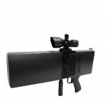
All Weather Passive Active Drone Detection Radar System Combo Radar Defensive System
|


|
Passive Active Drone Detection Combo Radar Defensive System Covers Large Areas Effectively
Ⅰ. Product Description
The Passive Active Drone Detection Combo Radar Defensive System is an advanced, integrated solution designed to detect, track, and mitigate unauthorized drone activities across large areas. This system combines passive RF detection and active radar scanning to provide comprehensive airspace security, ensuring real-time threat identification and response.
Ⅱ. Product Features
1. Dual-Mode Detection Technology
Passive RF Detection: Monitors drone communication signals (Wi-Fi, RF, GPS) to identify and classify UAVs without emitting detectable signals. Active Radar Scanning: Uses high-precision radar to detect drones based on size, speed, and trajectory, even in cluttered environments.
2. Wide Area Coverage
Detects drones within a5-10 km radius (depending on drone size and environmental conditions). 360° omnidirectional coverage ensures no blind spots.
3. RealTime Tracking Threat Assessment
Automatically classifies drones (DJI, Autel, custom-built, etc.) and differentiates them from birds or other flying objects. Provides real-time alerts with drone type, distance, speed, and flight path on an intuitive command interface.
4. Seamless Integration with Counter Drone Systems
Compatible with jamming, spoofing, and kinetic mitigation systems for automated or manual drone neutralization. Supports API integration with existing security infrastructure (CCTV, command centers).
5. Low False Alarm Rate
Advanced AI algorithms filter out false detections (birds, weather interference) while maintaining high sensitivity to drone threats.
6. All Weather Day/Night Operation
Works in rain, fog, dust, and complete darkness, ensuring 24/7 protection.
7. Portable Scalable Deployment
Modular design allows forfixed, mobile, or rapid-deployment setups (vehicle-mounted, temporary installations).Can be expanded into a multi-node networked systemfor wider perimeter security.
Ⅲ. Product Functions
1. Drone Detection Identification
Detects all types of drones (multi-rotor, fixed-wing, hybrid) across a wide frequency spectrum. Identifies drone model, operator location (if available), and payload risk assessment.
2. Automatic Threat Classification
AI-powered analysis distinguishes between friendly, suspicious, and hostile drones based on flight patterns and signal behavior.
3. Real Time Alerts Data Logging
Instant visual audio alerts on the command dashboard. Records all drone incursions for post-mission analysis and forensic evidence.
4. Multi-Layer Defense Coordination
Integrates with RF jammers, drone capture nets, and laser-based countermeasures for a complete defensive response.Supports manual or automated mitigation protocols depending on security requirements.
5. 3D Airspace Mapping
Displays drone movements in a 3D radar map with altitude, speed, and predicted trajectory.
6. Remote Monitoring Control
Accessible via web-based or standalone software, allowing operators to monitor airspace from a secure location.
Ⅳ. Product Parameters
VI:Product features
|
||||||||||||||||||||||||||||||||||||||||||||||||||||||||||||||||||||||||||||||||||||||||||||||||||||||||||||||||||||||||
| Product Tags: Passive Active Drone Detection Radar System All Weather Drone Detection Radar System All Weather uav radar systems | ||||||||||||||||||||||||||||||||||||||||||||||||||||||||||||||||||||||||||||||||||||||||||||||||||||||||||||||||||||||||

|
10km Range 1km Altitude Anti Drone System Dual-power supply design |

|
Precision Spoofing and Multi-Frequency Suppression Anti Drone System Omnidirectional Denial |

|
10 Km Passive Direction Finding Multi-Band Suppression Anti Drone System Web App Central Control |
|
Instant Detect 2km Precision Beam Anti Drone System 3s Takedown |

|
Instantaneous 3-second Attack 2-kilometer Beam Anti Drone System 10 Band Interference |

|
Multi Sensor All Round Protection Uav Radar Systems Safeguards Critical Zones |