
1:500 Regional Topography Model Architecture Hydrology Model Customized
|


Detailed Product Description
|
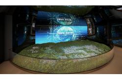
Architectural Model of Regional Topography and Hydrology for Urban
Planning and Environmental Display Product Description: This detailed architectural model vividly presents a large-scale topographical and hydrological landscape, incorporating mountains, rivers, lakes, urban areas, and infrastructure. Designed for urban planning, environmental education, and government exhibitions, the model uses precision techniques and vibrant materials to accurately reflect geographical features. The model integrates dynamic LED lighting and labeling for enhanced display and interactive presentations. Product Features:
Product Application:
FAQ: Q. How large a scale should the architectural model be to be
visually appealing? A: It is determined based on the size of the booth space location. Q: What kind of drawing materials are required for model making? A: Architectural model CAD sectional construction drawings or 3D
model files as well as renderings. Q: How long does the production cycle take? A: Usually within 30 natural days Q: How is the charge calculated? A: The cost is determined based on the size and scale of the
architectural model. Q: How about handling the transportation? A: We have long-term cooperative transportation providers and
exclusive customized transportation services tailored for the
global market. |
| Product Tags: 1:500 Regional Topography Model Architecture Customized Topography Model Architecture 1:500 Architecture Hydrology Model |
Related Products

|
1:50 1:100 1:500 Map Models Mountains Landform Model For Countries And Regions |

|
Architectural Model of Coastal and Park Masterplan with Mixed-Use Development, Water Features, and Green Space |

|
LED Architecture Topography Model 1:100 Topography Architecture Model |

|
1:500 Regional Topography Model Architecture Hydrology Model Customized |
Email to this supplier