
Lidar Cloud Map Matching And Environment Sensing Devices For Driverless Car Navigation
|
|
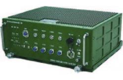
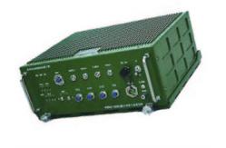
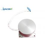
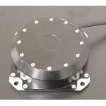
KsINS-L LiDAR point cloud map matching and environment sensing equipment product description: Based on inertial navigation information, satellite navigation information and liDAR/camera information, the liDAR point cloud map matching and environment sensing equipment can realize the functions of high-precision map matching and positioning, online precision mapping, typical target identification and tracking and relative distance measurement, etc., with high accuracy, strong versatility and high reliability. It can meet the requirements of real-time environment perception for autonomous driving and automatic following tasks.
Features: ● High precision. The relative positioning accuracy is better than 0.1m, and the absolute positioning accuracy of high-precision map matching is better than 1m. ● Strong versatility. Adopting a standard 6U chassis design to facilitate user product configuration ● Domestic, independent and controllable, using domestic Loongson 3A3000 processor and solid state drive ● The interface is highly scalable and can achieve "plug and play" integration with various types of information such as satellites, lidar, and visible light cameras. ● Strong environmental adaptability, can meet the vibration, impact and temperature environment of various types of unmanned vehicles, drones and unmanned ships
Application fields and application modes: Land use, navigation, drones, and can also be extended to other applications.
System performance:
System features:
Company Information
|
||||||||||||||||||||||||||||||||||||||
| Product Tags: Driverless Car Navigation Environment Sensing Devices Lidar Environment Sensing Devices | ||||||||||||||||||||||||||||||||||||||
|
Dynamically Tuned Gyroscope For Well Logging for Temperature Sensor |
|
Well Logging Dynamically Tuned Gyroscope For High Temperature Environment |
|
Single Axis Fiber Optic Electronic Gyroscope Sensor Shocking Resistance |
|
Gyroscope/Angular velocity sensor/Used to measure the angular velocity in the direction of the sensitive axis |

|
AI vision inertial navigation system for aircraft lifting assistance with weight ≤2.0kg |
|
State-of-the-Art Inertial Navigation System Aviation for Aviation Applications with Navigation accuracy (takeoff) 1.0m |