
High Precision Laser Strapdown Inertial Navigation System Based On 3 Axis Laser Gyroscope
|
|
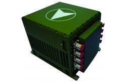
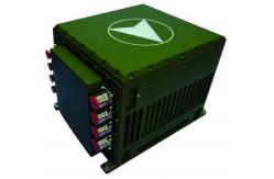
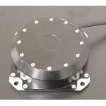
KsINS-90L type laser strapdown inertial navigation system product description: The KsINS-90L -type inertial navigation system is a standard high-precision laser strapdown inertial navigation system. It has the advantages of small size, light weight, high precision, and good reliability. It can meet the needs of long-term autonomous navigation in complex environments and is suitable for In various short-term navigation, integrated navigation, guidance and control and other fields. The heading alignment accuracy is better than ≤0.3mil (1σ), and the pure inertial navigation accuracy is better than 0.5nmile/h (CEP). The system can integrate satellite, radio, barometric altimeter, Doppler, odometer and other information to achieve high-precision integrated navigation. Features: ● 15kg lightweight high-precision laser strapdown product, 40% cheaper than traditional products ●Using domestic high-precision spatial three-axis laser gyroscope and quartz flexible accelerometer ●Space three-axis laser gyroscope bias stability is better than 0.001°/h (1σ) ●Accelerometer bias stability is better than 30μg (1σ) ●Achieve static and dynamic base alignment, and can choose self-alignment, on-the-fly alignment or transfer alignment according to user needs ●It can be integrated with various information such as satellites, odometers, altimeters, star sensors, etc. for combined navigation, and the interface has strong scalability
Application fields and application modes: Land use, navigation, drones, and can also be extended to other applications.
System performance:
System features:
Device performance:
|
|||||||||||||||||||||||||||||||||||||||||||||||||||||||||||||||||||||||||
| Product Tags: Lightweight Inertial Navigation System 3 Axis Laser Gyroscope Navigation System Laser Strapdown Inertial Navigation Unit | |||||||||||||||||||||||||||||||||||||||||||||||||||||||||||||||||||||||||
|
Dynamically Tuned Gyroscope For Well Logging for Temperature Sensor |

|
Well Logging Dynamically Tuned Gyroscope For High Temperature Environment |
|
Single Axis Fiber Optic Electronic Gyroscope Sensor Shocking Resistance |
|
Gyroscope/Angular velocity sensor/Used to measure the angular velocity in the direction of the sensitive axis |

|
AI vision inertial navigation system for aircraft lifting assistance with weight ≤2.0kg |
|
State-of-the-Art Inertial Navigation System Aviation for Aviation Applications with Navigation accuracy (takeoff) 1.0m |