
FS60-UAV Hyperspectral Imaging Camera With High SNR IP45
|
Detailed Product Description
|
FS60- UAV hyperspectral measurement system Fs60 UAV hyperspectral measurement system adopts high
signal-to-noise ratio and ultra-high speed CCD imaging device to
provide high stability spectral image acquisition; The
self-developed high-efficiency and low-power image processing
algorithm greatly prolongs the flight time of the whole machine and
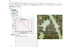
reduces the power consumption of the system. Through real-time measurement of spectral image information of
plants, water, soil and other ground objects, it is applied to
precision agriculture, crop growth and yield evaluation, forest
pest monitoring and fire prevention monitoring, coastline and
marine environment monitoring, lake and watershed environment
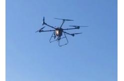
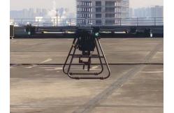
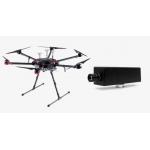
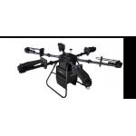
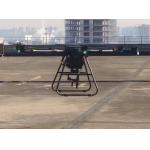
monitoring and other applications. ♦Dji M300RTK (DJI M600Pro optional) is used as the flight bearing
platform. ♦Ultra-high speed spectral scanning imaging device with high
signal-to-noise ratio provides high stability of spectral image acquisition. ♦A self-developed high efficiency and low power image processing
algorithm is adopted to greatly prolong the flight time of the whole machine and reduce the power
consumption of the system. ♦Through real-time measurement of spectral image information of
plants, water, soil and other ground objects, it can be applied to precision agriculture, crop growth and
yield assessment, forest disease and insect pest monitoring and fire monitoring, coastline and marine
environmental monitoring, lake and watershed environ mental monitoring and other applications. ♦The system design is compact and the main spectral resolution of
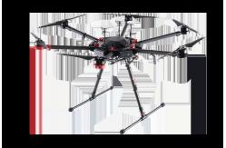
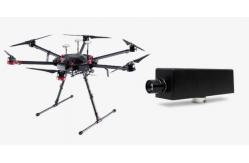
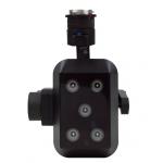
the imaging spectrometer is up to 2.5nm. Components: high stability head, hyperspectral imager,
embedded data acquisition and processing storage unit, wireless image transmission system, GPS-RTK navigation
system, ground receiving workstation, ground control system, reflectance calibration board. Applications Technical parameters Flight unit parameters (M300RTK)
Hyperspectral camera parameters
♦Easy to operate, it can achieve single operation without
professional drone operator. ♦The ground station can be used to observe the sampling location of
the aircraft in real time, and the ground station can be used to set
the preview and correction functions of the route data collected point-by-point: radiosity correction, reflectance correction and
regional correction support batch processing. ♦Real-time common vegetation index calculation function. ♦Support custom real-time analysis model input function. ♦ENVI is perfectly compatible with multiple data formats. |
|||||||||||||||||||||||||||||||||||||||||||||||||||||||||||||||||||||||||||||||||||||||||
| Product Tags: UAV Hyperspectral Camera High SNR Hyperspectral Imaging Camera Passive Lighting Hyperspectral Imaging Camera |
Related Products
|
Multispectral Camera FS-500 600 620 |
|
|
15 Megapixels Hyperspectral Imaging Camera For Advanced Oil Spill Detection With CHNSpec FS-60 |
|
Hyperspectral Imaging Camera For Advanced Oil Spill Detection With CHNSpec FS-60 |
|
FS60 Hyperspectral Imaging Camera For Precision Agriculture And Environmental Monitoring |

|
FigSpec FS-50 High Performance Hyperspectral Imaging Camera For Water Assessment |
|
FigSpec FS-50 Hyperspectral Imaging Camera For Water Assessment And Environmental Protection Decisions |
Email to this supplier