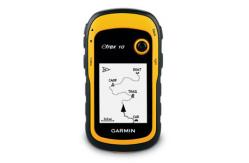
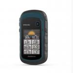
eTrex 10 retains the core functionality, rugged construction,
affordability and long battery life that made eTrex the most
dependable GPS device available. We improved the user interface and
added a worldwide basemap, paperless geocaching and support for
spine-mounting accessories.
See the Way
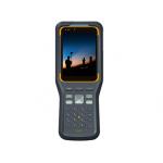
eTrex 10 has an enhanced 2.2" monochrome display that’s easy to
read in any lighting situation. Both durable and water resistant,
eTrex 10 is built to withstand the elements. Its easy-to-use
interface means you’ll spend more time enjoying the outdoors and
less time searching for information. eTrex 10 features the
legendary toughness that’s built to withstand the elements. Dust,
dirt, humidity, water — none are a match for this navigator.
Find Fun
eTrex 10 supports geocaching GPX files for transferring geocaches.
Visit OpenCaching to start your geocaching adventure. By going
paperless, you're not only helping the environment but also
improving efficiency. eTrex 10 stores and displays key information,
including location, terrain, difficulty, hints and descriptions,
which means no more manually entering coordinates and paper
printouts. Simply upload the GPX file to your eTrex 10 and start
hunting for caches.
Keep Your Fix
With its high-sensitivity, WAAS-enabled GPS receiver and HotFix®
satellite prediction, eTrex 10 locates your position quickly and
precisely and maintains its GPS location even in heavy cover and
deep canyons. Whether you’re in deep woods or just near tall
buildings and trees, you can count on eTrex 10 to help you find
your way when you need it the most.
Go Global
eTrex devices are the first-ever consumer-grade receivers that can
track both GPS and GLONASS satellites simultaneously. When using
GLONASS satellites, the time it takes for the receiver to “lock on”
to a position is (on average) approximately 20 percent faster than
using GPS. And when using both GPS and GLONASS, the receiver has
the ability to lock on to 24 more satellites than using GPS alone.
Plan Your Next Trip
Take charge of your next adventure with BaseCamp™, software that
lets you view and organize maps, waypoints, routes, and tracks.
This free trip-planning software even allows you to create Garmin
Adventures that you can share with friends, family or fellow
explorers. BaseCamp displays topographic map data in 2-D or 3-D on
your computer screen, including contour lines and elevation
profiles.
| General | |
| Physical dimensions | 2.1" x 4.0" x 1.3" (5.4 x 10.3 x 3.3 cm) |
| Display size, WxH | 1.4" x 1.7" (3.6 x 4.3 cm);
2.2" diag (5.6 cm) |
| Display resolution, WxH | 128 x 160 pixels |
| Display type | transflective, monochrome |
| Weight | 5 oz (141.7 g) with batteries |
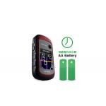
| Battery | 2 AA batteries (not included);
NiMH or Lithium recommended |
| Battery life | 25 hours |
| Water rating | IPX7 |
| High-sensitivity receiver | Yes |
| Interface | USB |
| Maps & Memory |
| Basemap | Yes |
Custom POIs
(ability to add additional
points of interest) | Yes |
| Waypoints/favorites/locations | 1000 |
| Routes | 50 |
| Track log | 10,000 points, 100 saved tracks |
| Outdoor Features |
| Geocaching-friendly | Yes (Paperless) |
| Hunt/fish calendar | Yes |
| Sun and moon information | Yes |
| Area calculation | Yes |
| Garmin Connect |
Garmin Connect compatible
(online community where you
analyze, categorize and
share data) | Yes
|