
0.3mm Accuracy Surveying Instrument 24 Keys
|


|
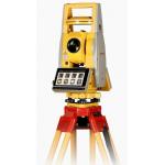
Surveying Instrument High Precision Digital Level 0.3mm Accuracy 24 keys with LCD screen for leveling
Description: FOIF brand EL03 digital level adopts the international mainstream software design, optimizes the line measurement, and strictly follows the grade measurement specification process, so that the level measurement work is simple and efficient, and is suitable for all level measurements of the first class and below. Its digital measurement method not only has excellent performance and easy operation, but also can greatly improve the measurement efficiency.
FOIF EL03 Digtal Level Features: 1. The round-trip horizontal observation accuracy per kilometer is 0.3mm, and the minimum reading is 0.01mm; 2. Large graphical LCD screen, easy to operate and easy to learn, can quickly obtain high-precision elevation information; 3. Add numeric keys and function keys (24 keys) to quickly input valid information; 4. Advanced photosensitive reading system, visible white light can be measured; 5. Comfortable hand-held handle design, easy to carry in the field; 6. Large-range automatic compensation, high leveling accuracy; 7. The digital reading system effectively reduces errors and repetitive operations, automatically records measurements, completely eliminates the interpretation errors of manual readings, and can easily generate reports and improve work efficiency; 8. Diversified data export methods, can be quickly exported through USB cable or SD card, exporting data is more convenient; 9. Equipped with measurement trigger key, after aiming at the staff, you can quickly start the measurement; 10. Support single-point measurement, multiple line measurements, positive/reverse staff mode switching, intermediate point measurement, stakeout, continuous measurement line adjustment function, and the horizontal network adjustment function can be realized in the post-processing software;
EL03 Level Application: 1. Leveling net measurement 2. Deformation monitoring and land subsidence monitoring 3. Industrial measurement 4. Tunnel and mine surveys 5. Topographic survey, leveling line survey, area leveling survey, leveling net survey, contour line survey 6. Road and railway construction stakeout, longitudinal section measurement, cross-section measurement, elevation stakeout
Specifications:
|

|
0.3mm Accuracy Surveying Instrument 24 Keys |

|
South New Technology Navi Station Total Station for Construction Surveying and Mapping |
|
|
South Navi Station 30x Magnification Surveying Instrument Total Station with 574 Channels Satellite Tracking and MT6753 Processor |

|
Total Station Navi Station 45mm Effective Aperture EDM 50mm by South 1'' Compensator Setting Accuracy for Standards |
|
|
574 Channels Satellite Tracking Surveying Instrument Measurements Total Station with 0.3-3s Measure Interval and Dual-Band WLAN |
|
Total Station Circular Vial 8'/2mm and TFT LCD Screen Dual Display South Navi Station for Your Survey Work |