
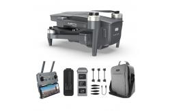
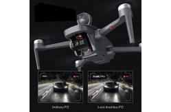
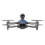
Aerial Photography Drone 3 Axis Gimbal Professional 4K Video Camera with Avoid Obstacles
|
|
Aerial Photography Drone 3 Axis Gimbal Professional 4K Video Camera with Avoid Obstacles
Specification
Description
Remote Sensing Drone, also known as a UAV (Unmanned Aerial Vehicle) or UAS (Unmanned Aerial System) for remote sensing, is an unmanned aircraft equipped with specialized sensors and cameras used to collect data and imagery from a distance for various scientific, environmental, and applications. These drones are specifically designed for remote sensing purposes, allowing for the collection of valuable information about the Earth's surface, atmosphere, and environment.
Features
Applications
|
||||||||||||||||||||||||||||||||||||||||||||||||||||||||||||||||||||||||||||||||||||||||||||||||||||||||||||||||||||||||||||||||||||||||||||||||||||||||||||||||||||||||||||||||||||||||||||||||||||||||||||||||||||||||||||||||||||||||||||||||||||||||||||||||||||||||||||||||||||||||||||||||||||||||||||||||||||||||||||||||||||||||||||||||||||||||||||||||||||||||||||||||||||||||||||||||||||||||||||||||||||||||||||||||||||||||||||||||||||||||||||||||||||||||||||||||||||
| Product Tags: 10km Remote Sensing Drones Remote Sensing Drones Agriculture Crop Monitoring Drone 1080P | ||||||||||||||||||||||||||||||||||||||||||||||||||||||||||||||||||||||||||||||||||||||||||||||||||||||||||||||||||||||||||||||||||||||||||||||||||||||||||||||||||||||||||||||||||||||||||||||||||||||||||||||||||||||||||||||||||||||||||||||||||||||||||||||||||||||||||||||||||||||||||||||||||||||||||||||||||||||||||||||||||||||||||||||||||||||||||||||||||||||||||||||||||||||||||||||||||||||||||||||||||||||||||||||||||||||||||||||||||||||||||||||||||||||||||||||||||||

|
Drone With 4k Camera And Gps 3 Axis Gimbal Professional Drones |
|
Aerial Photography MINI Drone With 4K Camera 3axis Gimbal UAV Professional GPS 5km Control Distance |
|
Professional Drone with 3-Axis Gimbal 4K Camera Faith2 SE Drones |
|
Professional Drone With 4k camera and gps Lidar Obstacle Avoidance Long Range UAV |

|
Professional Photography Drone with 3axis Gimbal 4k Camera and GPS Long Range UAV |
|
Drone 3 Axis Gimbal Professional 4k Camera Aerial Photography Uav Gps Long Range Drones |