
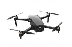
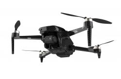
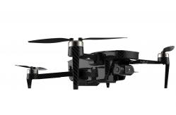
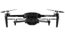
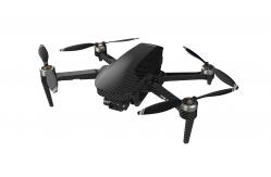
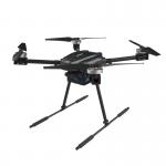
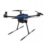
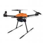
ZAi 1080P 10km Search Rescue Drone With 3 Axis Gimbal Camera
|
|
|
| Parameters | Value |
|---|---|
| Aircraft | |
| Product Name | ZAi 1080P 10km Search Rescue Drone |
| Model No. | ZAi-Faith 2T |
Size | Unfold:191 X 262 X 107 mm (L*W*H) Fold: 179X 108 X 74 mm(L*W*H) |
Wheelbase | 280 mm |
Weight (Battery & Propellers Included) | 562g |
Max Ascent Speed | 4m/s(sport mode) 3m/s(Normal mode) |
Max Descent Speed | 3m/s(sport mode) 2m/s(Normal mode) |
Max Service Ceiling Above Sea Level | 4000 m |
Max Flight Time | 32 mins |
Operating Temperature Range | ﹣5°C~45°C |
Satellite Positioning Systems | GPS/GLONASS |
Hover Accuracy Range | vertical: +/- 0.5 m ± 0.2 m(ultrasonic system,optical flow system works) horizontal: +/- 1.5m ± 0.3 m(ultrasonic system,optical flow system works) |
Operating Frequency | 2.4G |
Maximum flight height | 120m |
Optical flow system | |
Operating Environment | Surface with clear pattern and adequate lighting (lux > 15) |
Velocity Range | ≤1.5 m/s at 6.6 ft (2 m) above ground |
Altitude Range | 0.5~5m |
Ultrasonic altitude system | |
Operating Environment | except for the surface of water or ground of absorbing material
(such as thick carpet) |
Velocity Range | ≤ 3m/s |
Altitude Range | 0.2-4.5m |
3-axis gimbal | |
| stabilization | 3-axis(pitch:+30/-120°,roll:± 30°,course:±30°) |
| controllable range | pitch:-90°~20° |
Jitter Amount | 0.01° |
Normal camera | |
| sensor | SONY CMOS |
| image size | 3840*2160(8mp) |
| video recording resolution | 2716×1524(2.7k)25FPS |
| supported file system | FAT32(<=32GB) /exFAT(>32GB) |
| video | MP4 |
| operating temperature range | 0°C~40°C |
Thermal imaging infrared camera | |
| sensor | Vanadium oxide uncooled infrared focal plane detector |
| zoom | 4.3mm |
| sensor resolution | 256×192 @25Hz |
Infrared temperature measurement accuracy | ±2℃ or ±2% |
| measuring range | Industrial temperature measurement: -15 ℃~150 ℃ (high image quality) 50 ℃~550 ℃ (wide range) |
Digital zoom | 8X |
Effective measurement distance (person) | about 150m |
Pixel spacing | 12 μm |
Wavelength range | 8-14μm |
| photo format | R-JPEG |
| video format | MP4 |
Temperature measurement method | Point temperature measurement, Regional temperature measurement |
| focusing mode | Non-thermal prime lens |
| support for file system | FAT32 |
Support for storage card types | MicroSD card, with a maximum support of 128GB and a the transmission speed of UHS-I Speed Grade 3 rated Micro SD card. |
APP | |
Mobile App | C-Fly Go |
Maximum FPV transmission distance | 10km |
Resolution | 1080p |
| compatible operating system | Andriod 6.0 above, IOS 10.0above |
Remote Controller | |
Operating Frequency | 2.4GHZ |
Screen type | LCD |
Screen size | 5.5 inch |
Resolution | 1080p |
maximum transmission distance | 10km |
| EIRP | <26 dBm(FCC),<20 dBm(CE/SRRC/MIC) |
| working time | about 4 hours |
| operating temperature range | ﹣5°C~45°C |
| charger type | USB-C |
Product Advantages
- small body size powerful performance: high-quality carbon fiber body texture
- infrared thermal imaging technology: it can observe day and night
- visible light camera, dual camera channel
- digital image transmission distance of up to 10 kilograms
- optical flow positioning hovering
- 3-AXiS Micro Gimbal
- duration time 30 minutes
Product Application
This infrared thermal imaging foldable surveillance drone with a 10km flight distance, and a 30-minute range, can capture clean photos and night scene videos, it has excellent noise suppression ability, perfect for electric power inspection, reconnaissance, and drawing.
|
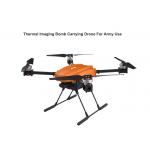
Bomb Carrying Thermal Imaging Drone For Army Use 10km 46 Minutes Payload 3kgs |
|
ZAi Lightweight Dual Light Pod 2.4G Foldable Remote Control Army Drone Mavlink Protocol |
|
1080P 10km Heavy Load Drone With Advanced Satellite Positioning Systems HK-M300 |
|
3000g Load Industrial Grade Drone 1080P 10km Foldable Camera Drone HK-M300 |
|
Industrial 1080P 10 Km Range Drone 3000g Load Long Distance Drone With Camera |
|
1080P 10km Industrial Grade Drone Foldable Drones For Industrial Use |