
SIYI F9P RTK Module Centimeter Level Four-Satellite Mutilfrequency Navigation And Positioning System
|


Product DescriptionF9P RTK module is a high-accuracy centimeter-level four-satellite multi-frequency navigation and positioning system developed for flight control systems. Through real-time kinematic positioning technology,the 3D positioning accuracy is improved from meter level to centimeter level. lt integrates positioning, altitude detection and dual-module direction finding functions. RTK technology makes up for the shortcomings of traditional GPS, barometer, and magnetic compass, enables UAVs to adapt to complex magnetic field environments. It is easy to operate and supports all-weather operations, providing accurate and reliable system solutions for high-precision application scenarios such as surveying and mapping, geographic information, agriculture, forestry, water conservancy, environmental monitoring, urban planning, transportation, and marine development. Technical Specification
|
||||||||||||||||||||||||||||||
| Product Tags: Centimeter Level RTK Module Four-Satellite RTK Module Mutilfrequency RTK Module |

|
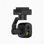
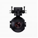
Four-Optical Pod Gimbals Drone Camera with GPS 3-Axis Gimbal and Thermal Imaging Laser Ranging ZT30 180-Degree Hybrid Zoom |

|
GPS 3-Axis Gimbal Drone Camera with 4K Camera and Four-Optical Pod ZT30 180-degree Hybrid Zoom Pod |
|
4K GPS 3-Axis Gimbal Camera Drone with Four-Optical Pod and Thermal Imaging Laser Ranging |

|
Thermal Imaging Laser Ranging Gimbals Drone Camera with 4K Camera and GPS 3-Axis Gimbal ZT30 180-Degree Hybrid Zoom Pod |
|
Drone Accessories 4K AI Hybrid Zoom Drone Pod with Four-Optical Pod and Gimbals |

|
Four-Optical Pod 4K AI Hybrid Zoom Drone Camera with GPS 3-Axis Gimbal ZT30 Thermal Imaging and Laser Ranging |