China Coastal Surveillance Radar manufacturer
Chongqing Leikan Technology Co., Ltd
Precision Beyond Sight, Safety with Leikan
1
Home > Products > Low Altitude Radar >

DBF Clutter Suppression Simultaneously track 300 batches of targets Low altitude monitoring radar Transmission power ≤ 30w

Browse Categories

Chongqing Leikan Technology Co., Ltd

Country/Region:china

Tel:86---18223329842

Contact Person:
Mr.Zheng
View Contact Details

DBF Clutter Suppression Simultaneously track 300 batches of targets Low altitude monitoring radar Transmission power ≤ 30w

Brand Name Lei Kan
Model Number LKST-X115
Minimum Order Quantity 1
Payment Terms L/C,D/A,D/P,T/T,Western Union,MoneyGram
Range Accuracy 5 km
Maximum detection height ≥ 2000 m
Keep track of the number of targets ≥300 batches
DBF Low equivalent omnidirectional radiation power and high search data rate
Detailed Product Description

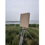
Ⅰ.  Product Overview


The LKST-X115 is  an X-band, fully coherent, one-dimensional digital beamforming (DBF) pulse Doppler radar specifically designed for monitoring low-altitude and near-ground composite targets. A single sensor can simultaneously detect, track, and output trajectories for no fewer than 300 batches of drones, personnel, vehicles, or surface maritime targets within a 360° azimuth and an elevation range of -3° to +60°, suitable for fixed station, vehicle-mounted, and portable deployments.


Ⅱ.  Product Features


1. High search data rate

digital beamforming, fast refresh rate


2. Adaptive clutter suppression

Rain, snow, and ground clutter do not trigger false alarms


3. Large pitch coverage

60 ° elevation angle meets mountainous and high-rise scenes


4. Record playback

Built in storage, supports post analysis


Ⅲ. Specifications


Parameter NameParameter Value
Operating FrequencyX-band 9.8–10 GHz
Elevation Coverage−3°–60°
Azimuth Coverage360°
Detection Range

Small quadcopter (RCS 0.01 m²) ≥ 8 km

Small fixed-wing UAV (RCS 0.1 m²) ≥ 12 km

Medium fixed-wing UAV (RCS 1 m²) ≥ 15 km

Personnel ≥ 14 km• Helicopter / vehicle ≥ 15 km

Maximum Detection Altitude≥ 2 000 m
Blind Zone≤ 50 m
Range Accuracy≤ 5 m (RMS)
Angular AccuracyAzimuth ≤ 0.4° (RMS) / Elevation ≤ 0.4° (RMS)
Antenna Rotation Speed30 rpm (180°/s)
upgradeable to 60 rpm (360°/s)
Simultaneous Tracks≥ 300
Tracking Speed Range1–150 m/s
Clutter RejectionImmune to common clutter
Operating Temperature−40 °C to +55 °C
Humidity≤ 60 %
Protection LevelIP65 (main unit IP67)
Weight≤ 35 kg
Power Consumption≤ 330 W
Array Dimensions540 × 675 × 85 mm
Resolution4° (azimuth) / 7° (elevation)
Transmit Power≤ 30 W


Ⅳ. Product selling points


1. Detection range (verified under Swirling-1 conditions with Pd ≥ 0.8 and Pfa ≤ 10⁻⁶):
 – Rotary-wing drone (RCS 0.01 m²) ≥ 8 km
 – Small fixed-wing UAV (RCS 0.1 m²) ≥ 12 km
 – Medium fixed-wing UAV/rotary-wing UAV/vehicle (RCS 1 m²) ≥ 15 km
 – Pedestrian (RCS 0.5 m²) ≥ 14 km
2. Airspace coverage
 – Azimuth: 0° to 360° Mechanical Continuous Scanning
 – Elevation: −3° ~ +60° electronically scanned coverage, elevation blind zone ≤ 50 m


3. Accuracy metrics (1σ, GNSS time synchronization)
 – Ranging ≤ 5 m RMS
 – Angular measurement (azimuth/elevation) ≤ 0.4° RMS

4. Capacity and Speed
 – Simultaneously track batches ≥ 300
 – Target speed range 1 ~ 150 m/s (≈ 0.06 ~ 5.4 km/h to 540 km/h)


5. Power Consumption and Weight
 – Total power consumption ≤ 330 W (including built-in computing, storage, and temperature control)
 – Antenna unit weight ≤ 35 kg, single-person transportable


6. Electromagnetic Security
 – Peak emission power ≤ 30 W, EIRP ≤ 33 dBm, complying with the public exposure limits specified in GB8702-2014


7. Interfaces and Extensions
Gigabit Ethernet: TCP/UDP ASTERIX CAT048, JSON, MQTT


Product Tags: low altitude radar with clutter suppression   low altitude monitoring radar 300 targets   low altitude radar 30w transmission power  
Related Products
Email to this supplier
 
From:
Enter your Email please.
To: Chongqing Leikan Technology Co., Ltd
Subject:
Message:
Characters Remaining: (80/3000)